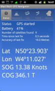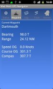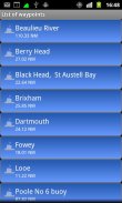


Mad Mutt Marine GPS Navigator

คำอธิบายของMad Mutt Marine GPS Navigator
I started writing this application as something that would be useful to me. Since that it has grown and I am rather pleased with it. It is an aid to marine navigation and must be used in conjunction with charts that are printed on that white stuff that is called (So I’m told) paper.
Features
•Designed by and for a sailor. You may find that some of the layouts look “big and blobby” at first sight, but they work at sea. Fiddly and fussy layouts do not.
•No network required. This app uses your phone’s GPS, it will work where there is no mobile network coverage (though you will need network coverage to share your logs and waypoints by email).
•Store unlimited waypoints (restricted in free version).
•View waypoints alphabetically of by distance from your current position.
•Display range and bearing to a waypoint.
•Make logs of where you have been, which you can annotate with comments and other relevant data.
•View logs as display on the phone.
•Share logs with Google Earth on your phone or desktop computer, either by email or by copying KML files.
•Share waypoints with Google Earth on your phone or desktop computer, either by email or by copying KML files.
•Share logs with Google Earth on your phone or desktop computer, either by email or by copying KML files. Although I don’t encourage the use of Google Earth for marine navigation, seeing your waypoints on Google Earth is a useful visual check that you have transcribed them correctly.
•Anchor watch alarm service. Alerts you if you have moved more than a pre-defined distance. The anchor watch also alerts you if the battery level is low.
•Near waypoint alarm service
•Once started, the log, anchor and waypoint alarm services will continue to run, even if you quit the main navigator application. They will continue to run while you make phone calls or use your phone for email, Internet browsing or pretty much anything else.
What this application is not
It is not a chart plotter. This application is intended for marine navigation. Although it could be used by ramblers, that isn’t the main intention. It does not display digitised charts, nor does it show you a Google Map view with your position displayed on it. I believe it is highly irresponsible to encourage the use of Google maps to navigate boats. Even in rivers and estuaries, Google maps contain no semantics for the sea whatsoever; no lights and marks, depths, rocks etc. The application does allow you to send logs you have made to Google Maps, though, but only after you have completed the trip.
Free Version
For a limited time, a free version is available. In the Autumn of 2012 a full feature version should be available.
The free version has the following limitations:
•The number of waypoints you can have is restricted to 20.
•Routes are not available
</div> <div jsname="WJz9Hc" style="display:none">ผมเริ่มเขียนโปรแกรมนี้เป็นสิ่งที่จะเป็นประโยชน์กับฉัน ตั้งแต่ที่มีการเจริญเติบโตและผมมีความยินดีกับมันค่อนข้าง มันเป็นความช่วยเหลือไปยังนำทางทางทะเลและต้องใช้ร่วมกับแผนภูมิที่ถูกพิมพ์ลงบนสิ่งที่สีขาวที่เรียกว่ากระดาษ (ดังนั้นฉันบอก)
คุณสมบัติ
•ออกแบบโดยและสำหรับกะลาสี คุณอาจพบว่าบางส่วนของโครงสร้างที่มีลักษณะ "ขนาดใหญ่และ blobby" ที่แรกเห็น แต่พวกเขาทำงานในทะเล รูปแบบเที่ยวยุ่งยิ่งและไม่จุกจิก
•เครือข่ายไม่จำเป็นต้อง app นี้ใช้ GPS ในโทรศัพท์ของคุณก็จะทำงานที่มีเครือข่ายครอบคลุมหมายเลขโทรศัพท์มือถือ (แม้ว่าคุณจะต้องครอบคลุมเครือข่ายการแบ่งปันบันทึกและจุดของคุณโดยอีเมล์)
•จุดเก็บได้ไม่ จำกัด (จำกัด ในรุ่นฟรี)
•ดูจุดตามลำดับตัวอักษรของความห่างของระยะจากตำแหน่งปัจจุบันของคุณ
ช่วงการแสดงผล•และแบกไป waypoint
•ตรวจบันทึกของที่คุณได้รับซึ่งคุณสามารถใส่คำอธิบายประกอบกับความเห็นและข้อมูลที่เกี่ยวข้องอื่น ๆ
•ดูบันทึกเป็นจอแสดงผลบนโทรศัพท์
•บันทึกแบ่งปันกับ Google Earth บนโทรศัพท์หรือคอมพิวเตอร์ตั้งโต๊ะของคุณทั้งทางอีเมลหรือโดยการคัดลอกไฟล์ KML
•จุดแบ่งปันด้วย Google Earth บนโทรศัพท์มือถือหรือคอมพิวเตอร์ตั้งโต๊ะของคุณไม่ว่าจะโดยทางอีเมลหรือโดยการคัดลอกไฟล์ KML
•บันทึกแบ่งปันกับ Google Earth บนโทรศัพท์หรือคอมพิวเตอร์ตั้งโต๊ะของคุณทั้งทางอีเมลหรือโดยการคัดลอกไฟล์ KML ถึงแม้ว่าผมจะไม่แนะนำให้ใช้ Google Earth สำหรับนำทางทางทะเลเห็นจุดของคุณบน Google Earth เป็นตรวจสอบภาพที่มีประโยชน์ที่คุณได้คัดลอกพวกเขาได้อย่างถูกต้อง
บริการปลุก• Anchor นาฬิกา แจ้งเตือนคุณหากคุณได้ย้ายมากกว่าระยะทางที่กำหนดไว้ล่วงหน้า นาฬิกาสมอยังแจ้งเตือนคุณหากระดับแบตเตอรี่ต่ำ
•ใกล้บริการปลุก waypoint
เริ่ม•เมื่อบันทึกสมอและ waypoint บริการปลุกจะยังคงทำงานแม้ว่าคุณจะออกจากโปรแกรมประยุกต์นำทางหลัก พวกเขาจะยังคงทำงานในขณะที่คุณใช้โทรศัพท์หรือใช้โทรศัพท์ของคุณสำหรับอีเมลท่องอินเทอร์เน็ตหรือสวยมากสิ่งอื่น
โปรแกรมนี้เป็นสิ่งที่ไม่
มันไม่ได้เป็นพล็อตกราฟ โปรแกรมนี้มีไว้สำหรับนำทางทางทะเล แม้ว่ามันจะถูกใช้โดยเดินเล่นที่ไม่ได้เจตนาหลัก มันไม่ได้แสดงแผนภูมิดิจิทัลหรือไม่ก็แสดงมุมมองแผนที่ของ Google ที่มีตำแหน่งของคุณที่แสดงบนมัน ผมเชื่อว่ามันเป็นความรับผิดชอบอย่างมากที่จะส่งเสริมการใช้แผนที่ Google เพื่อนำทางเรือ แม้จะอยู่ในแม่น้ำและอ้อยมีแผนที่ Google ความหมายไม่ว่ากรณีใด ๆ สำหรับทะเล; ไฟไม่และเครื่องหมายลึกหิน ฯลฯ โปรแกรมไม่อนุญาตให้คุณส่งบันทึกคุณได้ทำกับ Google Maps, แต่ แต่เฉพาะหลังจากที่คุณได้เสร็จสิ้นการ การเดินทาง
รุ่นฟรี
สำหรับระยะเวลาที่ จำกัด รุ่นฟรีสามารถใช้ได้ ในฤดูใบไม้ร่วงของปี 2012 รุ่นคุณลักษณะที่เต็มควรจะสามารถใช้ได้
รุ่นฟรีมีข้อ จำกัด ต่อไปนี้:
•จำนวนของจุดที่คุณสามารถมีถูก จำกัด ถึง 20
เส้นทาง•ไม่สามารถใช้ได้</div> <div class="show-more-end">


